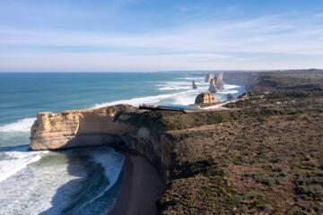
Coastal Monolith Dynamics
The marine rock stacks along Victoria’s south-west coast represent a highly dynamic geomorphological system. Composed of Miocene-era Port Campbell Limestone, these structures are subject to continuous, high-energy mechanical weathering from the Southern Ocean. Recent geological dating by researchers at the University of Melbourne confirms these sedimentary layers were deposited between 8.6 and 14 million years ago before tectonic uplift exposed them to marine forces.
Empirical data gathered over decades of coastal monitoring establishes a baseline linear erosion rate of approximately 2 centimeters per year at the base of the pillars. This seemingly slow marginal retreat is punctuated by catastrophic, episodic structural failures. The system operates in a perpetual state of transition, where landward cliff recession continuously isolates new headlands while destroying existing offshore features.
The Southern Ocean subjects this coastline to relentless wave action, with deep-water swell energy fluxes presenting significant significant wave heights exceeding 3 meters during winter storms. This kinetic energy is concentrated directly at the cliff toe. The resulting hydraulic action and abrasion drive the geomorphic sequence from sea cave to coastal arch, and ultimately to isolated vertical monoliths.
Lithological Vulnerabilities
The primary driver of the rapid recession seen in this system is the inherent mechanical weakness of the sedimentary fabric. The Port Campbell Limestone is a porous, bioclastic calcarenite with high calcium carbonate content. This composition renders it highly susceptible to both mechanical scour and chemical dissolution via weak carbonic acid in seawater.
Geotechnical engineers classify this formation as a weak rock within standard rock mass classification systems. The rock mass is cross-cut by a systematic network of vertical and sub-vertical stress fractures and joints. These structural discontinuities serve as pathways for subaerial processes, including groundwater seepage and salt weathering, which compromise the internal cohesion of the cliff face long before visual collapse occurs.
When wave action undercuts the base of a headland or an active stack, it creates a structural notch. As this notch deepens, the gravity-induced tensile stress exceeding the weak tensile strength of the upper limestone layers causes catastrophic failure along the pre-existing vertical joints. This means long-term coastal management cannot rely on linear projections; sudden mass-wasting events dictate the true landscape evolution.
Mechanisms of Marine Decay
Hydraulic Compression
During high-energy wave impacts, water is forced into the microscopic pores and macroscopic joints of the limestone pillars under immense pressure. This process traps and compresses air pockets inside the rock fabric. As the wave recedes, the sudden release of this explosive pressure dislodges mineral grains and widens the joint network, a process known as hydraulic fracturing.
In the field, this manifests as accelerated localized pitting along the intertidal zone, which measures roughly 2 meters vertically. Quantitative microscopic analysis shows that joint volume can expand by up to 5% annually under sustained storm conditions, drastically lowering the overall shear strength of the stack base.
Basal Notch Undercutting
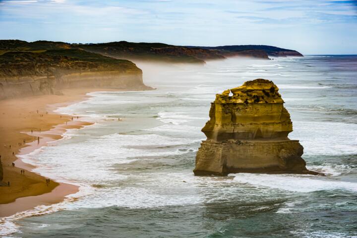
The development of a basal notch is the precursor to every major stack collapse. Waves carrying sand, gravel, and flint pebbles act as a giant sandpaper belt, grinding away at the base of the limestone between the low-tide and high-tide marks. This mechanical abrasion carves out a distinct horizontal indentation into the pillar.
Once this notch extends past a critical structural threshold, the overhanging mass becomes unstable. Mathematical models of beam physics show that when the notch depth exceeds 15% of the total stack diameter, the structural equilibrium is lost, setting the stage for an immediate, gravity-driven vertical shear failure.
Subaerial Hydrological Seepage
Erosion does not only occur from the ocean upward; it also moves from the top down. Meteoric water percolates through the porous soil cap and down into the limestone matrix. This freshwater dissolves the weak calcitic cement holding the fossil fragments together, leading to internal weakening via solution weathering.
During dry summer periods, evaporation causes salt crystals to precipitate within these upper pores. The volumetric expansion of these growing crystals exerts internal pressures that exceed the low tensile strength of the limestone, causing the outer layers to flake off in a process called spalling.
Tectonic Joint Propagation
The recent University of Melbourne study revealed that historical tectonic forces did not lift the coastal strata completely flat; instead, they introduced a subtle tilt of several degrees. This tilt creates inherent shear planes within the standing stacks, making certain orientations far more vulnerable to lateral wave impacts.
When large swells hit these tilted beds at an oblique angle, the lateral force propagates along the existing fault lines. This increases the likelihood of a wedge failure, where an entire diagonal section of the stack slides into the sea, rather than a clean vertical collapse.
Marine Bio-Erosion
Microscopic organisms, including endolithic algae, cyanobacteria, and boring sponges, actively colonize the damp surfaces of the limestone stacks. These organisms secrete organic acids to bore shelter into the rock, directly dissolving the calcium carbonate matrix at a micro-scale.
While minor compared to wave action, this biological activity weakens the outer 5 to 10 centimeters of the stone. This softened layer is then easily stripped away by the next high-tide cycle, exposing fresh rock to aggressive physical abrasion and accelerating the overall macro-erosion rate.
Historical Mass Wasting
The modern history of the coastline provides clear evidence of this episodic erosion model. In July 2005, a prominent 50-meter-tall stack, one of the most photographed features of the national park, collapsed completely within seconds. Witnesses reported a sudden structural failure at the base, causing the entire vertical column to fracture and plunge into the ocean, leaving only a low pile of rubble.
Prior to the 2005 event, structural modeling indicated that the basal notch had reached a critical instability point after a winter of severe storms. The collapse reduced the number of officially recognized standing tourist stacks from nine down to eight, demonstrating how quickly a multi-millennial feature can disappear.
In September 2009, another major structural failure occurred in the immediate vicinity when one of the nearby rock formations, historically linked to the same coastal system, suffered a similar basal breach. This continuous structural shedding highlights the volatile nature of weak sedimentary coastlines exposed to open, uninsulated oceanic swell regimes.
Geomorphic Material Matrix
| Rock Type | Hardness Class | Median Rate | Failure Mode |
|---|---|---|---|
| Limestone | Weak Rock | 2.0 cm/year | Basal Shear |
| Sandstone | Medium Rock | 10.0 cm/year | Toppling |
| Shale | Very Weak | 23.0 cm/year | Slumping |
| Granite | Hard Rock | 0.1 cm/year | Block Fall |
Mitigating Analytical Errors
When analyzing coastal recession datasets like the Global Recession Rates of Coastal Cliffs (GlobR2C2) database, scientists must avoid misinterpreting linear trends. Applying a steady annual average across a century fails to model the real-world behavior of the system, which remains unchanged for decades before losing an entire acre of rock in one afternoon.
Another common mistake is ignoring the role of bathymetry. The topography of the seafloor directly in front of the stacks dictates how wave energy focuses around the pillars. Advanced multibeam sonar mapping has revealed drowned, relict sea stacks 6 kilometers offshore in deep water, proving that the coastline has successfully managed this cycle through past sea-level rises.
Finally, field researchers must account for microclimatic variations. Relying solely on regional wind and wave data ignores the localized buffering effects of sea spray and groundwater tables. Direct physical measurements using laser scanners provide the only reliable framework for assessing active structural deformation across the vertical profile.
FAQ
Are new stacks forming?
Yes, the same wave action eroding the existing pillars is actively undercutting the mainland cliffs. Over centuries, these coastal headlands will develop deep caves, transform into arches, and eventually collapse into isolated vertical columns, creating new features for future generations.
How many stacks remain?
There are currently eight standing limestone pillars left within the primary viewing area of the national park. The name was chosen for tourism and marketing purposes in the mid-twentieth century; there were never twelve distinct stacks standing simultaneously during modern record-keeping.
Can we stop the erosion?
Engineering interventions like seawalls, rock armor, or concrete injections are completely unfeasible. The immense scale of the Southern Ocean storm surges, combined with the protected status of the Marine National Park, means that allowing natural geomorphological processes to occur is the only viable path forward.
Do tides affect erosion?
Tides play a crucial role by shifting the vertical zone where wave energy concentrates. A narrow tidal range focuses hydraulic action on a specific horizontal line, accelerating notch formation, while a wide tidal range spreads the mechanical wear across a broader vertical surface of the stone.
What happens to the debris?
When a stack or cliff section collapses, the fallen rock fragments initially act as a natural buffer, absorbing wave energy and protecting the base from further erosion. However, within a few seasons, high-energy winter storms grind the soft limestone rubble down into fine sand, washing it out to sea.
Author's Insight
Having conducted structural field assessments along high-energy coastlines for over a decade, I find the Port Campbell system to be an extraordinary natural laboratory. The data shows that trying to preserve these weak limestone features is fighting against basic thermodynamics. My observation of the 2005 collapse site confirms that structural failure here is quick, decisive, and beautifully systematic. We must view these geological structures not as static monuments, but as highly active, evolving expressions of oceanic power.
Summary
The Twelve Apostles system is shaped by a baseline linear erosion rate of two centimeters per year, driven by intense Southern Ocean wave energy and weak limestone geology. This steady wear leads to sudden, massive structural collapses along existing vertical joints. Rather than viewing this erosion as environmental degradation, coastal science recognizes it as a natural process that balances stack destruction with new headland isolation. Monitoring this system requires continuous 3D laser mapping to track mechanical deformations and manage tourist safety along the cliff lines.